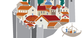

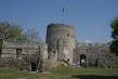
The castle


From the 5th
century
BC on, the
city of Kavala
was surrounded by a protecting wall. This was repeatedly modified over time - according
to sources,
extensive modifications
and repairs were
carried out after the Roman
period by Emperor Julian between
361 and 363, then by
Justinian,
and again in
926
by Basil Cladon, general of the Theme
of
Strymon. That being said,
the Byzantine wall probably owes its present form to Andronicus
II
Palaeologus,
who combined
the
fortifications with the
city's water supply,
following
the earlier
model
applied by Justinian
to Anastasioupoli.
Τhe fortifications
appear
to have been rebuilt and modified
throughout
the Byzantine period,
with
a new external
defensive
wall
being added to the city’s defences in the 16th century; the
northeast
section of this is still standing.
Following the
lie
of the land, the defensive wall
girdled the
hill,
encompassing an area of 13
hectares.
The enclosure
was reinforced
by
round
and
square towers
and bastions,
mainly
on the most
vulnerable land side to the north.
The perimeter is closed off by a
transverse
wall
449
metres
in length,
which climbs
a steep
slope
to the most
inaccessible
cliffs
on the north
side
to
a height of
64
metres.
The wall had
four gates to
facilitate movement into and
out of the city.
As part
of the
rebuilding projects carried out
to reinforce
the city’s defences,
the citadel of
Byzantine
and Ottoman
times
was built on
the hilltop site of its ancient counterpart.
The irregularly shaped
citadel fortifications
include
the northern
part
of
the city’s defensive
walls, reinforced by two
square towers on each
of the
northwest
and
northeast
corners,
a
polygonal
tower on the
east side and
a
bastion on the southeast. The area
inside
the citadel
is divided in
two by a transverse
wall running northwest - southeast, crowned at the central, highest point
by a cylindrical
tower.
The city’s defences also
included a 1.5 km long wall, which written
sources attribute to Andronicus
II
Palaeologus,
between 1307
and1308. It
was built
on the
occasion of
an
unsuccessful
attempt
by the
Catalans
to
conquer
Kavala,
and was primarily used to control
the road leading
from Macedonia
to Thrace via the city.
This
cross fortification
began
on
the north
side
of the city
walls
and led
to the
opposite
hills,
interrupted only by the aqueduct. It ended in three square towers and one round
one.
Glossary (0)
Information Texts (3)
Justinian I:
Byzantine Emperor
(527-565), nephew and successor of Justin I. One of his first acts was to
reform the tax system and recode Theodosius’ laws. He was personally involved
in religious conflicts and convened the 5th Ecumenical Council
(553). Justinian considered himself primarily an orthodox emperor and took
harsh measures against the remaining pagans. Many of his political and fiscal
actions provoked strong reactions on the part of the senate and the factions
and led to the Nika Riots. Justinian instigated numerous building projects,
erecting approximately 30 churches in Constantinople,
including the famous church
of Agia Sophia.
Regarding foreign policy, he successfully confronted the Persians and the
Vandals in the East and focused on the recovery of the West. This he temporarily
achieved, but at such cost that the Empire was left exhausted; the barbarians in
the Balkans plundered the Greek peninsula as far as the Isthmus and barbarian
tribes settled at the borders. His military operations exhausted Byzantium financially and
militarily and had no real effect, as Italy and other areas he conquered
were soon lost again. After his death, the weakened empire had to face new
attacks, culminating in the Arab conquests, which negated the majority of
Justinian’s conquests beyond the borders.
Themata:
Military units and divisions of territory. The themata
were instituted in the 7th century as a countermeasure against enemy
invasions. By the end of the same century most of the empire was subdivided in
this way. Themata were headed by a general who exercised military, political
and judicial power. Many such generals rapidly acquired considerable influence
and centralized power, so by the 8th-9th century the themata
were subdivided into smaller units to curb their influence. In the 11th
century the generals were replaced by civilian rulers, and by the late 12th
century the themata had ceased to exist.
The castle:
Anastasioupoli is located
near
the top of Lake
Vistonida, on
the fertile
plain
at the
foot
of the Rhodope
Mountains. From Roman times it was a staging post
on the Via Egnatia known
as
Stabulo Diomedis (=Diomedes’ Stables); tradition held it to be
the pastures of the wild and
bloodthirsty
horses
of Diomedes,
which only Hercules managed to
capture.
The
name
Anastasioupoli
is first attested by the
historian
Procopius, and is probably derived from Emperor
Anastasius
I
(491-518), who fortified it
for
the first
time.
After being destroyed by
Ivan Asan
in 1206,
and
re-founded
in 1341
by
Andronicus
III
Palaeologus, the city was
named
Peritheorio.
Anastasioupoli
Castle is polygonal in shape,
reinforced at intervals
with round
and
square
towers.
The city grew up in the 53 acres enclosed by the walls. The reign of Justinian
(527-565)
saw
two major construction projects at
Anastasioupoli. The
first was a cross wall built to
protect
the shore
zone
against
barbarian
raids
from the sea. The
second was a 4km long wall that served a dual purpose: on the one hand
it blocked off the crossing between the walls and the mountain, controlling
movement on the Via Egnatia,
and on the
other it served as an aqueduct, thus securing a supply of precious water from
the Rhodope Mountains. In the castle’s
final phase the
three
towers and central
arched
city gate were decorated
with
Palaeologus monograms in brickwork and
stone carving. The
interior of
the castle
now lies buried under
accumulated
earth
and lush
vegetation.
Bibliography (11)
1. Bakirtzis Ch., Byzantine Kavala: Archaeological survey, Thessaloniki, 1980
2. Ευγενίδου Δ., Κάστρα Μακεδονίας και Θράκης, Βυζαντινή Καστροκτισία, Athens, 1997
3. Καραγιάννη Φ., Οι Βυζαντινοί οικισμοί στη Μακεδονία μέσα από τα αρχαιολογικά δεδομένα (4ος – 15ος αιώνας), Thessaloniki, 2010
4. Τσουρής Κ., Λυχούνας Μ., ‘Νεάπολης – Χριστούπολης 300 μ . Χ. – 1391 μ. Χ’ in Η παλιά πόλη της Καβάλας (7ος π.Χ. – 20ος αι.), Ο χώρος, οι άνθρωποι τα τεκμήρια της ιστορίας, Καβάλα, 2005
5. Λυχούνας Μ., Μεσαιωνικό Υδραγωγείο Καβάλας. Καμάρες, Καβάλα, 2008
6. Η ακρόπολη της Καβάλας. Ιστορική εξέλιξη – Προτάσεις συντήρησης και αναβίωσης, Thessaloniki, 1980
7. Μπακαλάκης Γ., ‘Πύργος υπέρκαλος’ in Οίνος Ισμαρικός, τιμητικός τόμος για τον καθηγητή Γ. Μπακαλάκη, Thessaloniki, 1990
8. Μπακαλάκης Γ., ‘Το παρά την Χριστούπολιν τείχισμα’ in Οίνος Ισμαρικός, τιμητικός τόμος για τον καθηγητή Γ. Μπακαλάκη, Thessaloniki, 1990
9. Reinach M.S., La reconstruction des murs de Cavalla au 10 siecle, 1982
10. Στεφανίδου Α., Η πόλη - λιμάνι της Καβάλας κατά την περίοδο της τουρκοκρατίας. Πολεοδομική και ιστορική διερεύνηση (1391-1912), Καβάλα, 2007
11. Μπρίκας Α., ‘Νεάπολις- Χριστούπολις – Καβάλα. Διορθώσεις- Προσθήκες – Παρατηρήσεις στην οχύρωση και την ύδρευση’ in Μέρος Α’, Μελέτες, 1998
Comments (0)